by Dr Adrian Cooper
This discussion is presented in three parts. First, I will summarise the background and motivation behind this re-mapping project. Second, the discussion will examine the processes involved in creating the re-mapping outcomes shown here. Finally, I will consider the benefits and other consequences of re-mapping Storm Ciaran.
Background and Motivation
This re-mapping of Storm Ciaran was conducted by Felixstowe’s Citizen Science Group. To read an earlier article about their re-mapping work, please click here.
Storm Ciaran (also known as Storm Emir in Germany) was a wind and rain storm which affected parts of Europe between late October and early November 2023. Winds were recorded of up to 160 miles per hour or 260 km/h. Significant damage to property, and loss of life, was experienced (PA Reporters, 2023).
Re-Mapping Storm Ciaran
1: Why is the term ‘net zero’ interpreted in so many ways by governments and corporations?
2: Why has there been so little practical progress in reducing carbon emissions since the Paris Agreement (2015)?
3: Why are governments allowing the Ukraine and Middle Eastern Wars to distract from climate change strategy? Can they not multi-task?
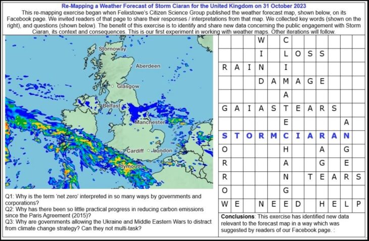
In that first publication of the Storm Ciaran forecast map, the Felixstowe Citizen Science Group also shared a ‘cross word’ style assembly of key words in order to provoke further debate among a wider readership. Within only five days, we received 117 private messages to the Felixstowe Citizen Science Group Facebook page – their highest number of messages for any single subject. That level of public response suggested that local people wanted to voice their emotions and insights about Storm Ciaran in a clear new way.
To develop our re-mapping of Storm Ciaran, we took the seven most frequently used themes from the Facebook feedback and arranged them into interview questions. Those questions were then discussed and refined among Felixstowe Citizen Science Group members.
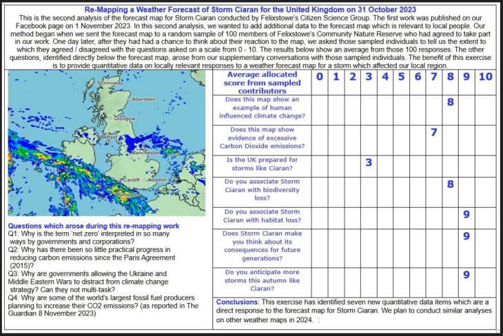
Interview questions were directed at 100 randomly chosen members of Felixstowe’s Community Nature Reserve. To organise that sample, Felixstowe’s Citizen Science Group appointed three Data Collection Team Leaders. Each Team Leader was allocated 6 – 8 Citizen Science Group members. That meant that 25 members of Felixstowe’s Citizen Science Group were involved in the research interviews. The list of 100 randomly chosen people was then divided among that data collection group with about 4 phone calls per group member.
The process for conducting those interviews began when we sent out the Storm Ciaran forecast map to 120 members of Felixstowe’s Community Nature Reserve. The first 100 to reply and acknowledge their willingness to participate in the re-mapping project received their research phone call the following day. In each case, those interviewees were asked the following questions:
- Does this map show an example of human influenced climate change?
- Does this map show evidence of excessive Carbon Dioxide emissions?
- Is the UK prepared for storms like Ciaran?
- Do you associate Storm Ciaran with biodiversity loss?
- Do you associate Storm Ciaran with habitat loss?
- Does Storm Ciaran make you think about its consequences for future generations?
- Do you anticipate more storms this autumn like Ciaran?
Interviewees were asked to indicate the degree to which they agreed / disagreed with each question on a scale from 0 – 10.. That is, a response of zero would indicate no agreement with the premise of the question. An answer of ‘10’ would indicate complete agreement with the question.
When all the scores were received, we took an average for each question and rounded them up to the nearest whole number. The benefit of this exercise is to introduce seven new sets of quantitative data to the forecast map which are of direct relevance to the interpretations of local people in Felixstowe. It would be interesting to see the results from other citizen science groups on other storms.
Clearly, further work can be done on ‘unpacking’ the answers identified in this re-mapping exercise. That work could begin in 2024.
In reflecting on this project, it is worth identifying some of the major risks and problems of this re-mapping:
- Data quality is always a matter of concern in any branch of citizen science. With any activity undertaken by Felixstowe’s Citizen Science Group, their Data Management Plan is a guide to rigorous standards in data collection, analysis and visualization.
- With any form of collaboration, such as promoting inclusiveness alongside re-mapping, there is always a risk of projects lacking coherence from the diversity of participants. Part of the answer to that challenge, which was employed by Felixstowe’s Citizen Science Group, was to allow time for extended debate among members. That is, we had no formal deadlines for the completion of our re-mapping. Instead, patience, empathy, good humour and clear leadership were allowed to prevail.
- If this re-mapping had failed to develop in the way it was first imagined, there might have been a risk of reputational damage to Felixstowe’s Citizen Science Group. However, if the project had not completed in the way it did, we would like to think that stakeholders would have interpreted that difficulty in a positive light – ie one that saw apparent failure as a learning opportunity from which further iterations of the project might be developed.
The benefits of this re-mapping
- This re-mapping exercise has given local people in Felixstowe a way of expressing their responses to Storm Ciaran in both quantitative and qualitative data.
- Seven sets of quantitative data have been identified. Subsequent research may ‘unpack’ those data into further interview questions with members of Felixstowe’s Community Nature Reserve, and possibly others.
- This exercise shows that an inclusive approach to map making, and to re-mapping, can produce finished work which is rich in an abundance of ideas and further questions.
- Particularly among people who had never made maps before, it is clear that their enthusiasm to do more map making has increased as a consequence of participating in this work on Storm Ciaran.
- It is hoped that other citizen science groups, including school science groups, will find value in this work, and will subsequently complete similar projects of their own.
Conclusions
This re-mapping exercise has shown that Storm Ciaran had both physical and cultural dimensions. For example, the floods and wind damage from Storm Ciaran impacted significantly on the experiences and memories of local people in the Felixstowe area.
Re-mapping has been shown to have clear political dimensions too. Re-mapping allows its authors to include data and information which is of importance to them, instead of those people feeling they have to passively accept maps created by elite groups such as Ordnance Survey or the Met Office.
Re-Mapping also shows how its authors identify with an environment through their most significant questions, passions, disillusionment, fears and hopes. As such, this discussion may be aligned with the work of the Cultural Geographer, Denis Cosgrove and his ‘Mappings’ book from 1999.
References
Cosgrove D (1999) Mappings (Reaktion Books)
Edwards, Lucy E. (30 November 2015). “What is the Anthropocene?”. Eos. Vol. 96. doi:10.1029/2015EO040297
PA Reporters (2023) South of England and channel Islands bear the brunt of Storm Ciaran.