by Dr Adrian Cooper
This discussion is presented in three parts. First, the background and aims of the re-mapping project are introduced. Second, the process of creating the project is explained. Finally, an indication is provided of where this type of re-mapping work might lead.
This re-mapping project was completed by the 36 members of Felixstowe’s Citizen Science Group (FCSG). Their Facebook page provides information on their previous work and original aims.
FCSG’s re-mapping project is intended to challenge the types of data which are employed within map making. The case study of Newbourne Springs Nature Reserve in Suffolk was voted on by FCSG members because it is a place which is significant to all members.
Maps are an attempt to represent an environment, landscape or place. They are the product of interactions between the map makers’ imaginations and the objectivity of the area under consideration. Those interactions become problematic when it is appreciated that people respond to their surroundings in different ways. For example, some map makers may choose to show boundaries and routes in their work. Others may prefer to identify economic resources. The forms in which maps may appear is almost endless.
This re-mapping project is an attempt to represent Newbourne Springs Nature Reserve in ways which are important to FCSG members. It is therefore intended to be used alongside other maps of the Nature Reserve, such as those created by the Suffolk Wildlife Trust. It is not intended to be seen as any kind of criticism of those official maps.
FCSG discussed their method of re-mapping Newbourne Springs throughout May 2023. On 1 June, all members attended a group-walk of the Nature Reserve, using the perimeter path as well as other paths across the area. During the walk, members took notes about features which they wanted to include in the re-mapping project. In addition, artists within the group began drawings of the landscape, trees, marsh, grasses and wild flowers. Creative writers in the group also recorded individual words and lines of poetry. Musicians began to compose melodies in response to their experiences. Those members with children were encouraged to take them to the walk. Those children were encouraged to share what they felt to be important about the Nature Reserve. Most FCSG members chose to repeat the walk, alone or in smaller groups, up to 5 June. A second group-walk was organized for 8 June when 33 members were able to attend. Children were also invited. Again, members came away from the walk with more notes, sketches, photographs, sound recordings and memories.
This re-mapping project appreciates the importance of walking as a way of thoughtfully engaging with an environment. Walking therefore identifies the value of personal geographies which embody ways of thinking, and ways of responding to an environment, which are the product of independent thought and creativity. Personal geographies are not passive. Instead, they are active and continually becoming. They are rarely static. They connect people with places. Often, personal geographies will be confronted, contested and marginalized by other ways of seeing, and ways of responding to an area. However, a core belief within this re-mapping project holds that democratized geographies (ie geographies of independent thinkers) should find a place alongside mainstream maps and other methods of representing a landscape.
Another key feature of this remapping project is that it emphasizes FCSG members’ experiences of place, rather than their judgements. That is, while judgements about a location imply a sense of completion and finality in conclusions, FCSG’s preferred focus on geographical experiences accommodates a preference on personal geographies as works in progress: always becoming, and always open to further development.
In the days after the 5 June group-walk, FCSG members conducted Zoom meetings to develop a high-level initial map of Newbourne Springs Nature Reserve. The results of that work are shown below.
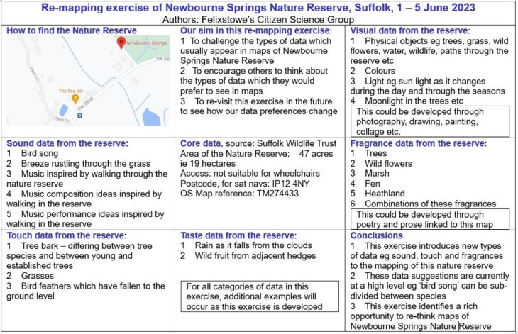
This map locates Newbourne Springs Nature Reserve using conventional referencing (see central panel). The Conclusions panel, in the lower right section, clearly identifies three areas which can be developed in future iterations of this work. However, the main feature of the map shown above is its inclusion of multi-sensual data. That is, data drawn from visual, aural, taste, touch and fragrances. Regarding visual and fragrance data, the panels on the right hand side of the map suggest possible ways in which they might be expressed and shared. Future iterations of this work might identify other methods, such as modern dance which is filmed and attached to the map as mp4 files.
In response to the map shown above, FCSG’s next iteration of this re-mapping exercise was to reduce the scale of their map from the entirety of the Newbourne Springs Nature Reserve to just a 200 metre length of path. The reason for that decision was simply to experiment with the potential abilities of FCSG’s approach to re-mapping. The results of that micro-scale re-mapping are shown below.
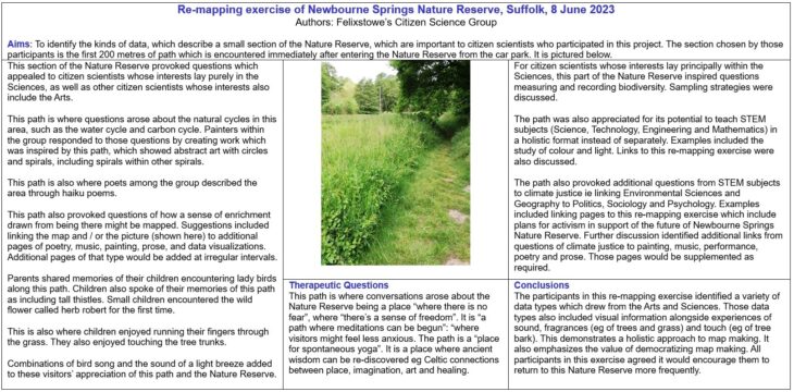
Once again, this second map includes multi-sensual data. However, the development of this second map also identified therapeutic questions. Those are included in the lower central panel of the map. Having identified those therapeutic features of the Newbourne Springs Nature Reserve path, they could be fed back into the first map shown earlier in this discussion.
An additional feature of this second map is that children felt more able to identify key features of the area than they did when they were asked (by their parents) to re-call the full area of the Nature Reserve.
In developing the two maps shown above, FCSG members did not always agree on what was to be included and excluded. Final decisions were taken by vote among the group.
FCSG members also found themselves surprised by parts of the final maps. Members from a purely scientific background, for example, found themselves approving of the multi-sensual data, even though none of them had worked with those data types before. Those same members also found themselves surprised about the inclusion of therapeutic questions and references to ancient wisdom in the second map. Again though, they took no persuasion that those data types are consistent with a re-mapping project which is created by a mixed group of citizen scientists.
Maps which include such a richness of data types inevitably require thought about their Data Management implications. FCSG therefore turned first to its Data Management Plan and found no inconsistencies or other concerns. In particular, the maps shown above do not infringe FCSG’s approach to GDPR requirements. Equally, they present no problems concerning FCSG’s Information Security Management System (ISMS). Zoom meetings which reviewed these maps, and this article, also examined FCSG’s Risk Management within its ISMS. Again, no problems were found. However, while it is reassuring to reach those conclusions at the time of writing, it was unanimously agreed that questions of Data Management must remain on the agenda to manage and develop this re-mapping project.
FCSG members agree that more can be done in the re-mapping of Newbourne Springs Nature Reserve. The group also wishes to encourage other groups of citizen scientists and conservationists to re-map locations which are important to them. FCSG hopes there will be a cross-fertilization of ideas between groups who engage in re-mapping.
FCSG members have agreed that future iterations of this re-mapping project must include a greater attempt to improve inclusiveness. That is, FCSG will reach out to other groups and individuals in the Felixstowe area to seek their input on future maps of Newbourne Springs as well as other local areas. Initial thoughts on that improved inclusiveness include work, which has already been instigated, between FCSG and the Chill Yard youth project in Felixstowe. Three areas of inclusiveness have been identified: (i) More people of diverse religious faith; (ii) More women; and (iii) More young people ie people up to the age of 25. Critics of this list may suggest that people of colour should be included. However, initial research on that question suggests that people in Felixstowe prefer not to be categorized through their skin colour. Instead, attributes of faith, gender and age are preferred. In other regions, outside the Felixstowe area, inclusiveness in re-mapping may need to focus on alternative criteria in response to local preferences. Other critics of FCSG’s inclusiveness strategy may question the apparent absence of any reference to LGBTQ+ identities. However, FCSG is happy to welcome those inputs through any of its three inclusiveness criteria identified above. FCSG intends to organize its inclusiveness work in five ways: (i) Strategy, including policy and governance; (ii) Design; (iii) Implementation; (iv) Operation; and (v) Continual improvement.
When greater thought has been given to these questions of inclusiveness in FCSG’s re-mapping project, it is hoped that a Powerpoint presentation can be offered to the Inclusiveness and Diversity Working Group of the European Citizen Science Association to explain FCSG’s thinking at that time, and to request input from that Working Group. Contact details of the Working Group have already been found. It is estimated that the Powerpoint presentation will be ready in the Autumn / Winter of 2023 / 2024.
FCSG members drew great value from a wide diversity of relevant literature in developing this re-mapping project. In particular, Jamie Lorimer’s Wildlife in the Anthropocene was helpful in its recognition that ideas about nature and environments always reflect cultural histories. Equally, Jeffrey Jerome Cohen’s edited essays Prismatic Ecology shows that responses to landscape and place should not be reduced to purely “green” readings. Cohen and his contributors therefore recognize that notions and representations of ecologies are often more complex and disordered than has been previously assumed. Finally, Catriona Sandilands book The Good Natured Feminist seeks to promote new dialogues between eco-feminism and radical Geography. Sandilands also encourages further debate between Ecology, Geography and identity politics. Finally, Sandilands encourages activism to arise from these debates. In sharing these titles however, FCSG agrees that many others could, and should, be recognized for their great value.
Five conclusions may be drawn from this discussion:
- The re-mapping of Newbourne Springs Nature Reserve by FCSG is intended to supplement other maps, and not criticize or replace them, such as those maps created by Suffolk Wildlife Trust.
- The re-mapping of Newbourne Springs Nature Reserve by FCSG has identified significant data types, such as the multi-sensual data and therapeutic questions, which can be explored further when the group decides it to be necessary.
- Data Management questions are fundamental to this re-mapping project. They will remain on FCSG’s agenda for all future iterations of this work.
- Innovation is also essential to this re-mapping project. Fresh ideas will be encouraged at each monthly Zoom meeting which FCSG members hold.
- Inclusiveness will become fundamental to the innovation process. That is, FCSG recognizes that added richness of inputs to the innovation process should lead to an enhanced production of data-rich new maps.
Ultimately, FCSG hopes that this discussion, and its re-mapping project generally, will encourage other groups to engage in their own re-mapping work. Constructive feedback from those other groups would be greatly welcomed and should be directed to FCSG through its Facebook page.