Scotland’s environment web is working with partners including NBN Atlas Scotland, to mobilise environmental data, extending its reach and influence by turning it into accessible information and knowledge.
Written by Jo Muse, Principal Policy Officer, Scottish Environment Protection Agency
“Our ability to do great things with data will make a real difference in every aspect of our lives.” – Jennifer Pahlka, Founder and Executive Director for Code for America
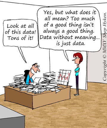
Many organisations collect and use data to perform their daily tasks. Often that data is used only once, for the specific task it was collected for and then hidden away within the deepest darkest depths of the filing system to never again see the light of day. That data can however be extremely useful to other data users, out with the task for which it was originally collected and often, out with the organisation that collected it. These wider users can take open data and use it in innovative ways to gain new insights and trends that can increase our understanding of the environmental challenges that need to be addressed, help to prioritise and inform decisions, and initiate positive action.
We have a responsibility to society, the economy and the environment to open up more data – to help target policy and decisions on the most important issues, to be more transparent to the public, encourage participation, and support innovation within a sustainable economy.
Open data is the release of non-commercially sensitive and non-personal public sector information. Open data does not contain personal information relating to individuals or information which could be used to identify individuals. (Open data strategy, Scottish Government, 2015). Open data is data that anyone can access, use or share. It should be shared in a standardised format so that it is easy to use and understand, and easily tracked back to where it came from. (Open Data Institute).
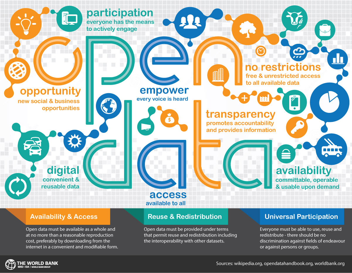
Since the publication of the Scottish Government open data strategy, more and more data has been openly published across the public sector. With portals such as the Scottish Spatial Data Infrastructure (SSDI) Metadata Portal and data.gov.uk – it is much easier to find and discover open data. But more data doesn’t always mean more information…..
Unlocking information from data
Environmental data underpins so many different activities – carrying out assessments; applying for grants and permits; making decisions on environmental impacts; carrying out research; learning at school about statistics, science, and geography; and understanding more about the very environment in which we live and work. We all have questions we want to answer, and with the right data that is accessible in the right format, we can retrieve those key nuggets of information that help us reach the right answers. So it is important to have access to data that is trusted and authoritative, relevant to the big questions, is current and up-to-date, and available in a useful format.
“Web users ultimately want to get at data quickly and easily.” Tim Berners-Lee
Since its inception in 2011, Scotland’s environment website has been developed as a consumer of open data, transforming it into accessible and understandable information. Embracing the concept of a Shared Environment Information System (SEIS), a high proportion of data tools and services on Scotland’s environment website rely on live open data services published by our partners, that make a wide range of environmental data more accessible to multiple users and uses, and reduces the risk of different versions of data being used. Users can therefore be confident they are viewing the most up-to-date published data, and all stakeholders within a decision-making pipeline can have access to and view the same data – one version of the truth.
How does Scotland’s environment website use open data?
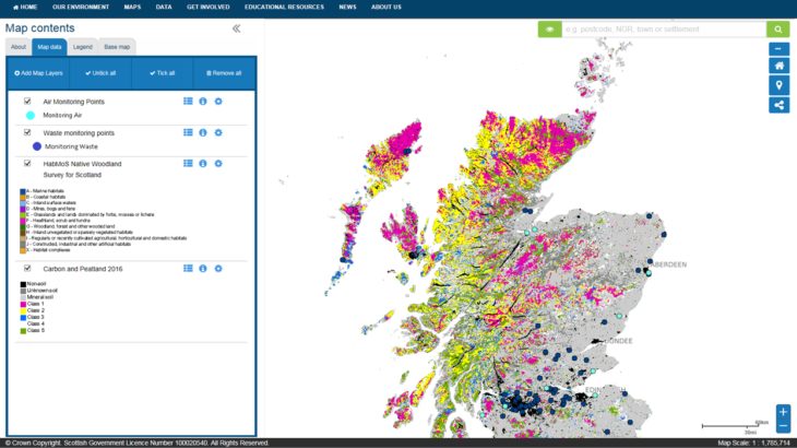
SCOTLAND’S ENVIRONMENT MAP draws on over 200 publicly available Web Map Services from a range of partners and external sources. This is the only place you can view any combination of environmental spatial data in a single map tool.
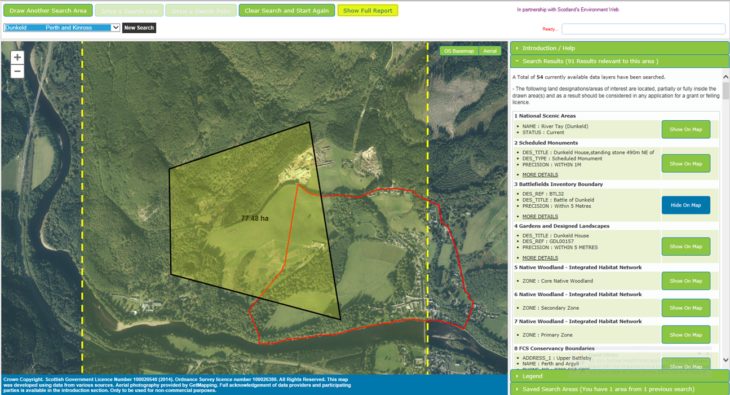
LAND INFORMATION SEARCH
This tool allows users to carry out instant spatial queries on over 40 open data sets published by different organisations as ESRI Rest services. These applications help users quickly identify environmental features, designations and sensitive areas fall within or close to a specific area of interest, that need to be taken into consideration when assessing the impact of current or proposed site activities for grants and licence applications, and environmental risk assessments.
DATA ANALYSIS THROUGH VISUALISATION
Scottish Natural Heritage publishes data that you can view in the PROTECTED NATURE SITES DATA ANALYSIS TOOL. The tool is able to provide an interactive, searchable visual analysis of the condition of Scotland’s most important nature sites.
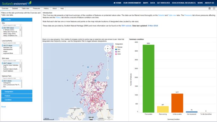
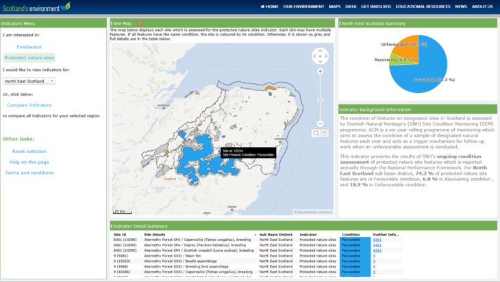
This open data is also used in the ECOSYSTEM HEALTH INDICATORS TOOL which is used to report on progress in delivering the 2020 Challenge for Scotland’s Biodiversity and prioritise action to protect and enhance ecosystem health. The data has been transformed into three summary indicators for Protected Nature Sites of Favourable, Recovery and Unfavourable. Users can view the indicators at a national Scotland summary…
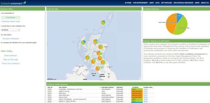
or at a more area specific catchment area level.
Open Data Collaboration
Realising the full value of open data is a collaborative process with the aim of providing benefits for all. Organisations need to share data and work together to create new uses for it that can help to solve problems in ways that might not have been anticipated. Collaborations between multiple partners, such as the Scotland’s environment web partnership, can help convert open data from insight into action. NBN is working with Scottish Natural Heritage and the Edinburgh Parallel Computing Centre, funded by the University of Edinburgh, on a project managed by DataLab to re-engineer the use of Scotland’s environment web partner open spatial data within the NBN Atlas. The aim of the project is to enable automatic upload and processing of open spatial data in the NBN Atlas. This will reduce the overhead of maintaining up to date spatial data for both the data providers and the NBN Trust, which at the moment is a manual process.
NBN Atlas Scotland is part of Scotland’s environment network – a growing network of trusted and authoritative sources of environmental, data and information.