Re-Mapping Abbey Grove, Felixstowe: A citizen science of data management, inclusiveness and influence on public policy – Written by Dr Adrian Cooper
This discussion is presented in three parts. First, I will describe the background to re-mapping the Abbey Grove area of woodland which is located in Felixstowe, Suffolk. In doing so, I will show how data management policies were implemented to ensure the best possible data quality. Second, I will explain how each of the three re-mapping exercises has also been an example of inclusiveness. Finally, I will discuss the ways in which the re-mapping of Abbey Grove is intended to contribute to the development of public policy concerning the plans to build across countryside which is immediately adjacent to Abbey Grove.
The re-mapping of Abbey Grove was conducted by Felixstowe’s Citizen Science Group (FCSG). In this context, re-mapping may be considered as an activity where members of the public create new maps containing the types of data which they consider to be important and helpful to represent their appreciation of a place or landscape. A more extensive discussion of re-mapping was published last year.
Data quality is an essential element in all citizen science projects. In this context, data quality is defined by FCSG by its accuracy, completeness, reliability, consistency, relevance, timeliness, validity and security in storage.
With regard to the re-mapping of the Abbey Grove woodland, Fowler et al (1998) was the most important source of guidance on ensuring data quality. It is a text which is discussed during training sessions for FCSG members in small groups of no more than five FCSG members. Additional support with its interpretation is also given on a one-to-one basis when it is needed. More recently, FCSG has greatly appreciated the work of European Citizen Science. In particular Soacha et al (2024) has been found to be particularly helpful. In response to that discussion, the following points may be made concerning the data life cycle of re-mapping Abbey Grove:
- Data planning – This first stage of the re-mapping and data life cycle process began in June 2023 within the established small-group format which is familiar to FCSG members. Specifically, it was emphasized that re-mapping of any place and / or environment involves the possible inclusion of data types which are important to the map-makers. Through discussion in the FCSG small groups, it was agreed that data would be drawn from woodland sights, sounds, fragrances, tastes (eg woodland berries) and touches (eg the experience of brushing one’s hand across tree bark, or through long grass). Discussions then considered how those data types might be recorded. Suggestions included mp3 files for sound data, jpeg files for photographs, mp4 files for video, and words for other data types.
- Data Collection – Large-group and small group walks through the Abbey Grove woodland are the basis of all data collection for the FCSG re-mapping exercises. Experiences of place are then either noted, or recorded in the case of mp3 and mp4 files. In addition, members of FCSG who wish to express their re-mapping work in sketches, drawings and paintings also develop that work from those walks. In this way, it is shown that walking is fundamental to personal geographies, the development of local knowledge, individual senses of place, and shared geographical interpretations of place.
- Data preparation – This stage of the data management process considered how the data might be presented on the final published maps. A significant feature of this stage was that there was no deadline placed on its completion. This has been an important feature of the re-mapping process because the FCSG leaders wanted to encourage all members to feel they had enough time to experiment with different formats of presentation for their maps. Through discussion among FCSG members, it was eventually agreed that the final maps should be presented on a single side of A4 paper, and then saved as a jpg file. In that way, the final maps could be uploaded onto the FCSG Facebook page. It could also be shared easily elsewhere.
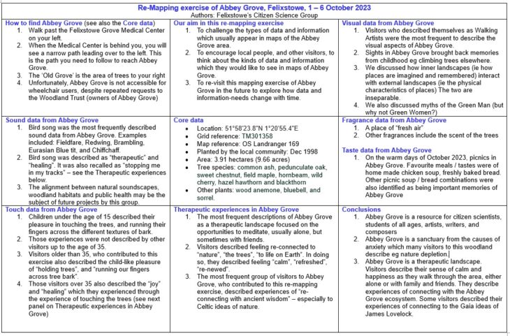
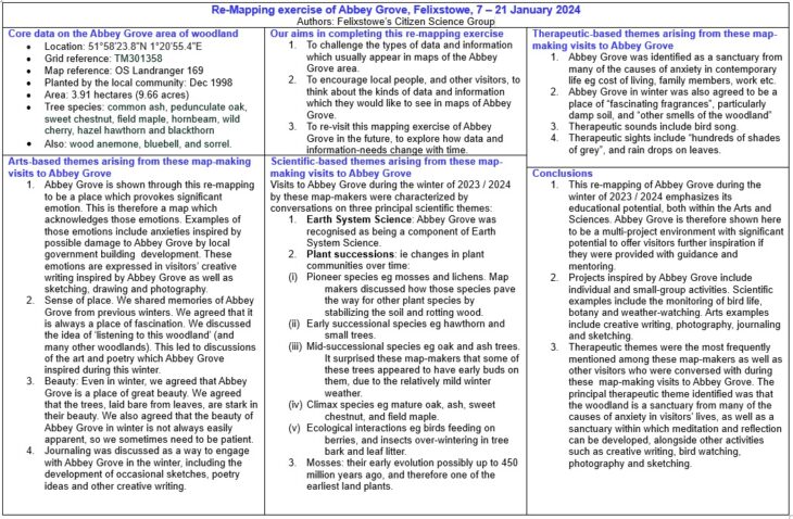
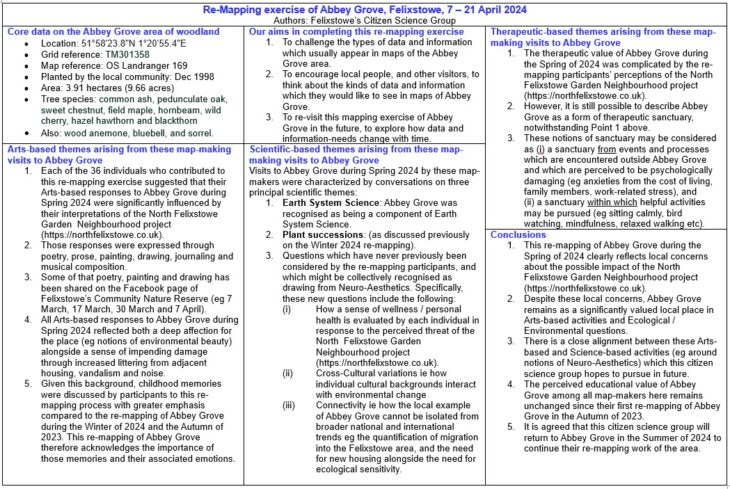
- Data Analysis – This stage involved collating all the data items and then organizing them into a framework which satisfied the aspirations of FCSG members. Although this might have been found to be a long and controversial process, it was actually found to be completed across two one-hour meetings. That was because the Data Planning stage of re-mapping had agreed on the principal data categories of sight, sound, fragrance, touch and taste data, along with therapeutic data describing how Abbey Grove is a place which is recognized by the map-makers for its benefits to mental and physical health.
- Data Storage – Each member of FCSG has kept their own notes which formed the basis of the re-mapping of Abbey Grove. In addition, FCSG leaders have kept minutes of all meetings devoted to re-mapping. These documents are also saved to the FCSG One Drive. They are also backed up on a USB Flash Drive.
- Data Publication – Each example of the re-mapping exercises is initially shared on the FCSG Facebook page. They are therefore available to be shared through the Facebook network by visitors to the FCSG page. More recently, the re-mapping work has been shared with the urban planning consultant which has been chosen to work with the local authority responsible to the Felixstowe area, that is East Suffolk Council.
Each of these six stages was recognised by FCSG as an opportunity to reflect on data quality.
Together, FCSG believes its approach to data management supports the standards for open science defined by UNESCO (2023).
The maps below are the finished re-mappings of Abbey Grove by FCSG for the autumn of 2023, winter 2024 and spring 2024 respectively.


The re-mapping of Abbey Grove during the summer of 2024 is currently in development and will be shared on the FCSG Facebook page.
The second part of this discussion focuses on the inclusiveness strategy employed by FCSG within its re-mapping of Abbey Grove. The main goals of that inclusiveness strategy are to invite as many women, young people under the age of 25, and people of faith as possible. Those goals are achieved by developing informal discussions with local people, followed by invitations for groups of them to join FCSG members on walks in the Abbey Grove area. Within those walks, the women, young people under the age of 25, and people of faith are encouraged to either contribute to the FCSG map making, or to create their own maps. So far, FCSG guests have preferred to contribute to FCSG group re-mapping work.
In reflecting on the inclusiveness goals of concentrating on women, young people under the age of 25 and people of faith, it is important to explain why people of colour and people identifying as LGBTQ+ do not appear to be included. In both cases however, FCSG members have not met any local people who define themselves only by the colour of their skin, or their LGBTQ+ orientation. Instead, so far, all guests have preferred to identify as either a woman, young person, or person of faith. FCSG respect those wishes.
A further essential reflection on the FCSG inclusiveness strategy is to recognize the very significant contribution which the women, young people and people of faith have made to the FCSG re-mapping. In particular, three themes have become very clear from the inclusiveness discussions. First, the guests emphasize notions of environmental aesthetics concerning Abbey Grove. Second, they discuss ideas of gratitude either to a deity, the global biosphere, and the local people who first planted Abbey Grove. Thirdly, the inclusiveness guests discuss the implications of the re-mapping for civic participation by FCSG members as well as other local people.
The final section of this discussion considers the ways in which the FCSG re-mapping of Abbey Grove has entered into discussions over local public policy. The context for that development arose in the North Felixstowe Garden Neighbourhood project (NFGN). See references below for the online link to that project.
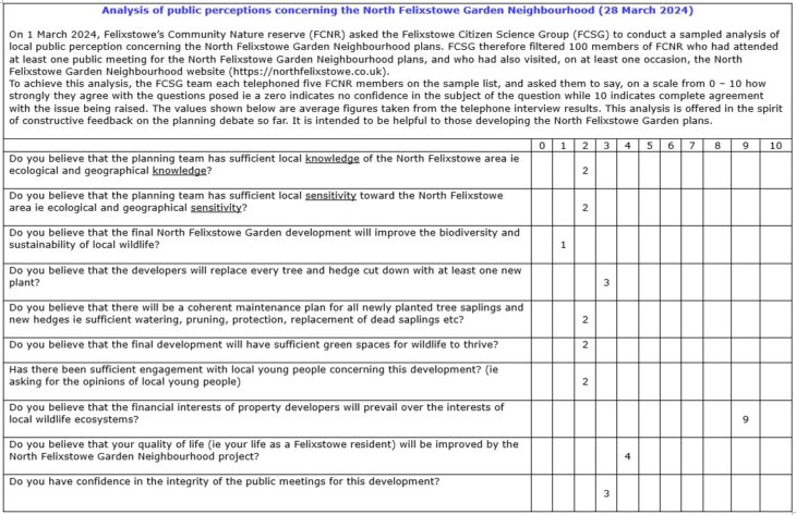
During the initial development of the NFGN, the urban planning consultant LDA contacted FCSG and asked them to share their work on re-mapping Abbey Grove. The role of LDA is to advise East Suffolk Council on the development of the NFGN project. A link to the LDA web pages is included in the references below. Earlier this year, FCSG published an investigation into local perceptions of the NFGN. A copy was sent to LDA.

After LDA had studied this investigation, they asked for the analysis to be repeated in July this year. That work is planned to be completed by the end of July.
These exchanges between LDA and FCSG have been validating and encouraging for FCSG members. More broadly, it shows that a citizen science group can produce work which is respected within the realms of public policy.
There are five main conclusions to draw from this discussion. First, data quality has been taken seriously by FCSG within its re-mapping of Abbey Grove. Training in data collection and data management techniques is a regular feature of FCSG’s re-mapping and other activities. As such, data management is part of FCSG’s commitment to being a learning organization (Cooper, 2019).
Second, inclusiveness has been incorporated into the project management of FCSG’s re-mapping work. Although diversity issues are intensely controversial and problematic, FCSG has shown a sustained sensitivity toward its importance. At each of FCSG’s monthly meetings, these issues are reflected upon and discussed openly.
The third conclusion shows that FCSG has built upon its re-mapping projects to share not only their re-mapping of Abbey Grove, but also the subsequent public perception analysis. It remains a source of encouragement to FCSG members that their work has been welcomed by the relevant urban planning consultant.
The fourth conclusion here locates this discussion within themes related to the Anthropocene (Lorimer 2015). That is, the re-mapping of Abbey Grove has been influenced by local concerns over biodiversity loss, land use change and climate change. Themes related to the Anthropocene continue to be of interest to FCSG and have been published on their Facebook page.
Finally, a host of further questions arise from this discussion. They include the need to confront adultism in the area of map making, and to encourage far greater production of new maps by young people. Equally, FCSG has found that people of faith have discovered an agenda for dialogue around environmental beauty, gratitude and civic participation. New maps arising from those inter-faith discussions will be encouraged by FCSG.
Ultimately, it is hoped that this discussion will inspire and encourage other groups to engage with re-mapping, and to share the results of their work.
References
Cooper AR (2019) Felixstowe Citizen Science Group becomes a learning organization, published in the newsletter of the National Biodiversity Network, December 2019, https://nbn.org.uk/blogs/nbn-blog/felixstowes-citizen-science-group-becomes-a-learning-organisation/ (online, accessed 22 June 2024)
Fowler J, Cohen L, and Jarvis P (1998) Practical Statistics for Field Biology (Wiley & Sons, Chichester)
LDA Design https://www.lda-design.co.uk/ (online, accessed 22 June 2024)
Lorimer J (2015) Wildlife in the Anthropocene, University of Minnesota Press
NFGN https://northfelixstowe.co.uk/index.php?contentid=30 (online, accessed 22 June 2024
Soacha K, Cardenas A, Alvarez A, Fabo C, Barba J, Haklay M, and Hernandez M (2024) Best Practices For Collaborative Development of Citizen Science Data Infrastructures pdf (online) https://zenodo.org/records/10635857 (Accessed 1 May 2024)
UNESCO (2023) Recommendation on Open Science (online) https://www.unesco.org/en/open-science/about (Accessed: 1 May 2024)
